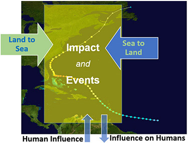

Warming oceans, seawater acidification, sea level rise, and other long-term environmental changes are part of the ongoing climate crisis that impacts the coasts. Episodic natural events, such as storms, flooding, and harmful algal blooms (HABs), also endanger the lives and livelihood in coastal communities. Similarly, our land use and presence along the coast affect the coastal ecosystem’s processes and health. These challenges are further compounded by the dynamic and complex coastal regions that are challenging to study. Consequently, understanding them and the processes and events within them necessitates a holistic, integrated approach that incorporates a variety of information, including that only available from satellite observations.
The Application Knowledge Hub (AKH) was created by the Center for Satellite Applications and Research of the National Oceanic and Atmospheric Administration's (NOAA) Satellite and Information Service in collaboration with the Committee on Earth Observation Satellites ' (CEOS) Coastal Observations Applications Services and Tools (COAST) and other partners. Its purpose is to provide a knowledge hub that maximizes using satellite-based observations to illustrate and visualize the impact of climate change and episodic events. The goal is to contribute to coastal ocean awareness, safety, and restoration efforts.
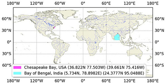
The CEOS COAST AKH is global in scope, yet there is a strong regional focus by taking advantage of high-resolution satellite data and contextual information. Following the CEOS COAST goals, we initially will focus on the coasts surrounding the US Chesapeake Bay and the Indian Bay of Bengal coasts. The AKH will expand to other coasts and small island nations.
For the Bay of Bengal area, we are actively collaborating with ISRO's Space Application Centre (SAC) . More details are coming.
For the Chesapeake Bay, NOAA STAR’s Satellite Oceanography and Climatology Division (SOCD) will continue its partnership with NOAA’s North Atlantic Regional Collaboration (NART) team to develop and evaluate satellite-derived data products. The hub will be a virtual toolbox of indicators to enhance partners’ understanding of communities along its shore and their vulnerability to flooding and water quality impacts.
Toggle CarouselThe AKH ingests satellite and non-satellite info (see Data section). Conceptual output types are listed here.
Map visualization, Timeseries of station data, Event maps (future)
Sea surface temperature, Chlorophyll-a, Sea level anomaly, Wind magnitude
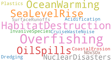
Episodic flooding due to storm events, Sea level rise (IPCC AR6)
Spectral analysis, Machine learning (e.g., Support Vector Machine)
Despite the known limitations in satellite capabilities for coastal applications, with improved sensor characteristics, they are attractive enough to be explored in conjunction with other available information to get the best value from an integrated approach and create a value chain for coastal awareness and applications.
Satellite data alone is insufficient for this task but provides the necessary backbone. However, integrating a vast amount of satellite and non-satellite observations (in situ, coastal classification, social indicators), advanced mathematical methods to compute derivative information (e.g., trends and shoreline changes), and modern visualization provide an opportunity to understand coastal changes.
Currently, this is work in progress. The hub is in its early days (beta). We will seek feedback soon as we capture a few checkpoints.